East of Greenville is being explored as one of the Focus Areas that will be evaluated as part of the General Plan Land Use Alternatives process. Similar to the other Focus Areas, three alternatives are being studied for the East of Greenville area. No housing is being proposed in the East of Greenville Focus Area. Information about East of Greenville related to the General Plan Update can be found on this page. Visit this page for more information on the General Plan Land Use Alternatives.
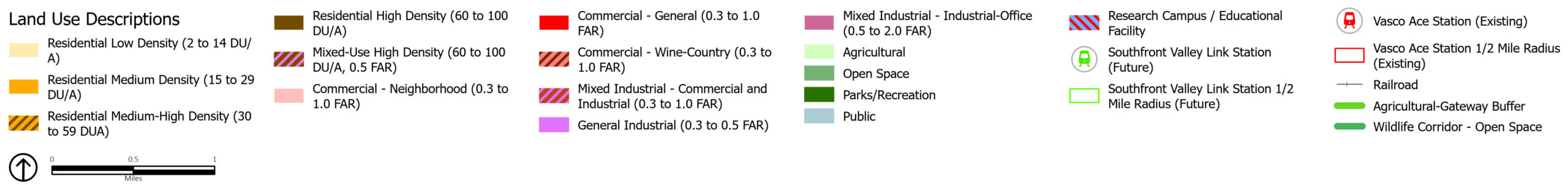
The Urban Growth Boundary (UGB) is defined as the boundary that urban development is not intended to go past. The intent of this boundary is to preserve the open space and agricultural land outside of it and contain urban development within it. There are two UGBs in Livermore. The South Livermore Urban Growth Boundary Initiative, passed by local voters in March 2000, established the UGB around the southern edge of the City. Any changes to the South Livermore UGB would require voter approval. In December 2002, the City Council adopted the North Livermore Urban Growth Boundary Initiative, which completed the UGB around the northern edge of the City. The UGBs surrounds (or includes) approximately 16,593 acres of land.
Sphere of Influence (SOI) is the term used for the area outside of the City Limits, which the City could reasonably expect to annex in future years. Livermore’s SOI is mostly the same as the City Limits but includes additional land in the north past Raymond Road, to the east past Greenville Road, to the south extending to Tesla Road, past Marina Avenue, and including certain portions of South Livermore Valley. The SOI includes approximately 21,468 acres of land.
A focus area represents an area in Livermore that could likely experience land use changes, places the community would like to see transition or redevelop with a different mix of uses, over the next 25 years. Potential focus areas are:
Focus areas are intended to be a combination of many parcels and are several acres in size. They are considered neighborhood or district in scale. The purpose of a focus area is to explore various and substantial land use changes compared to 1) the current site conditions and built environments, and 2) the land uses currently envisioned and allowed under the 2003 General Plan.
In addition to the focus areas, the General Plan will also update land use designations for specific parcels, as necessary, if a new land use designation would help fulfil the General Plan Vision. The combination of new land use designations in the focus areas and the new land uses for specific parcels or small areas that do not need intensive analysis will be combined to create the new General Plan Land Use Map.
Finally, focus areas are different from site planning or site remediation. Focus Areas will evaluate a range of uses that can achieve the broader General Plan Vision and the community’s long-term goals. Conversely, site planning and development occurs at the parcel level, is dependent on market factors, relies on private property owner decisions, and is how the General Plan land use map and designations are realized over time.
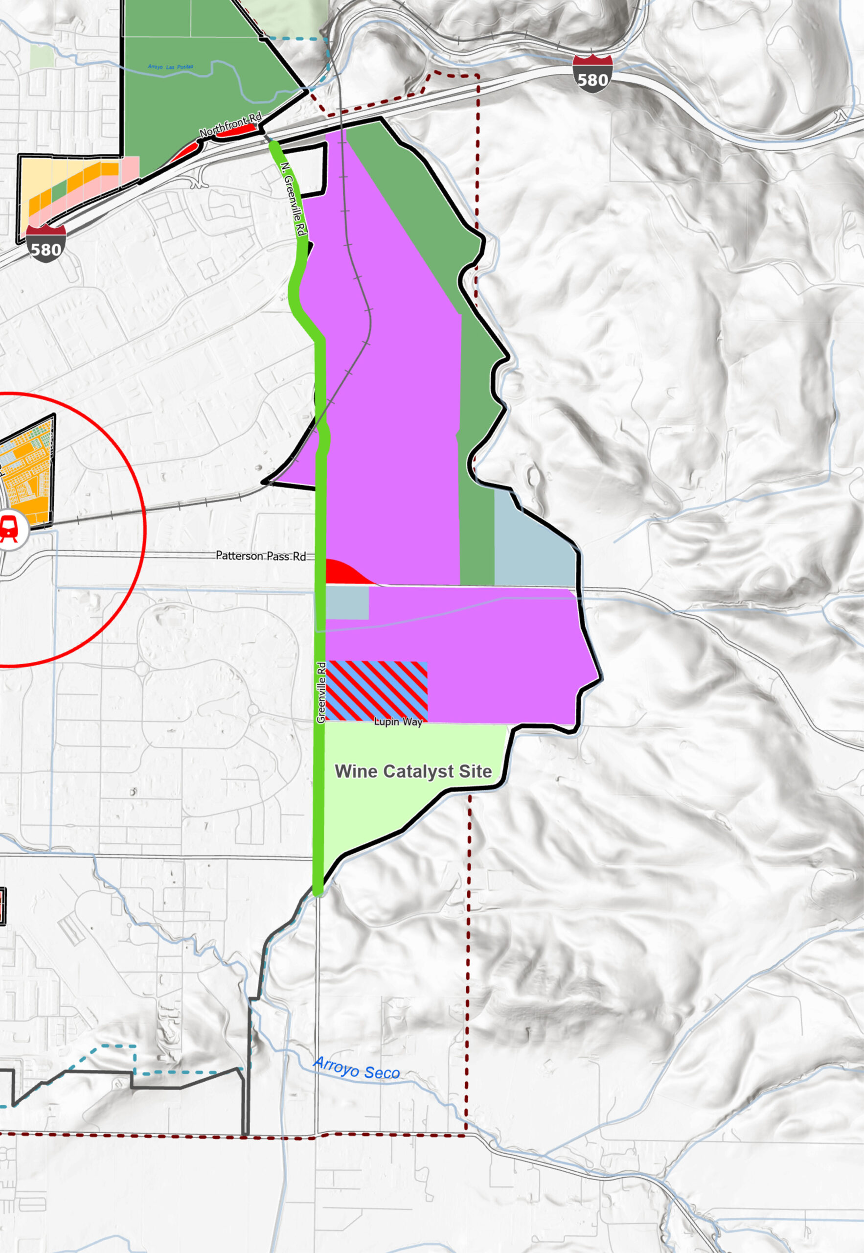
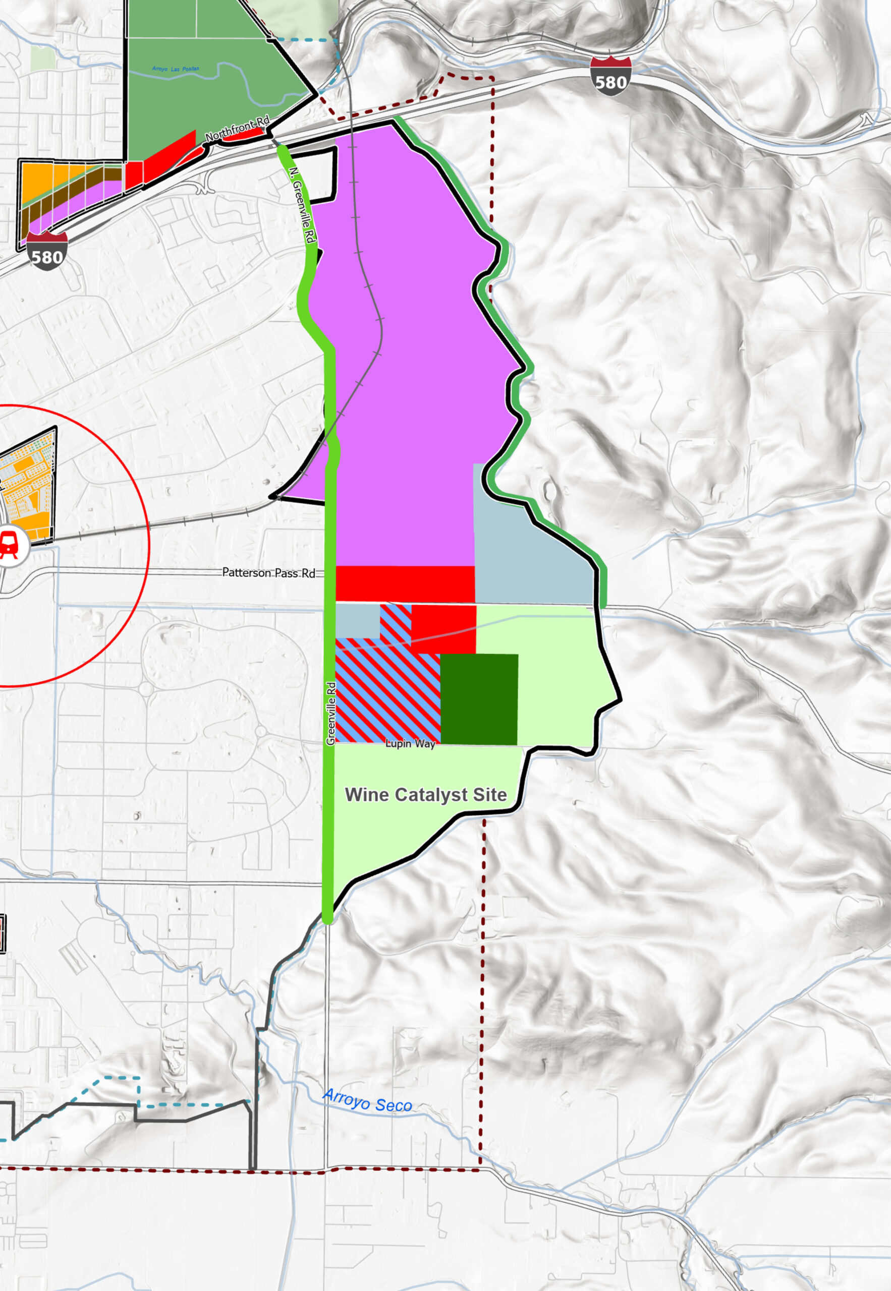
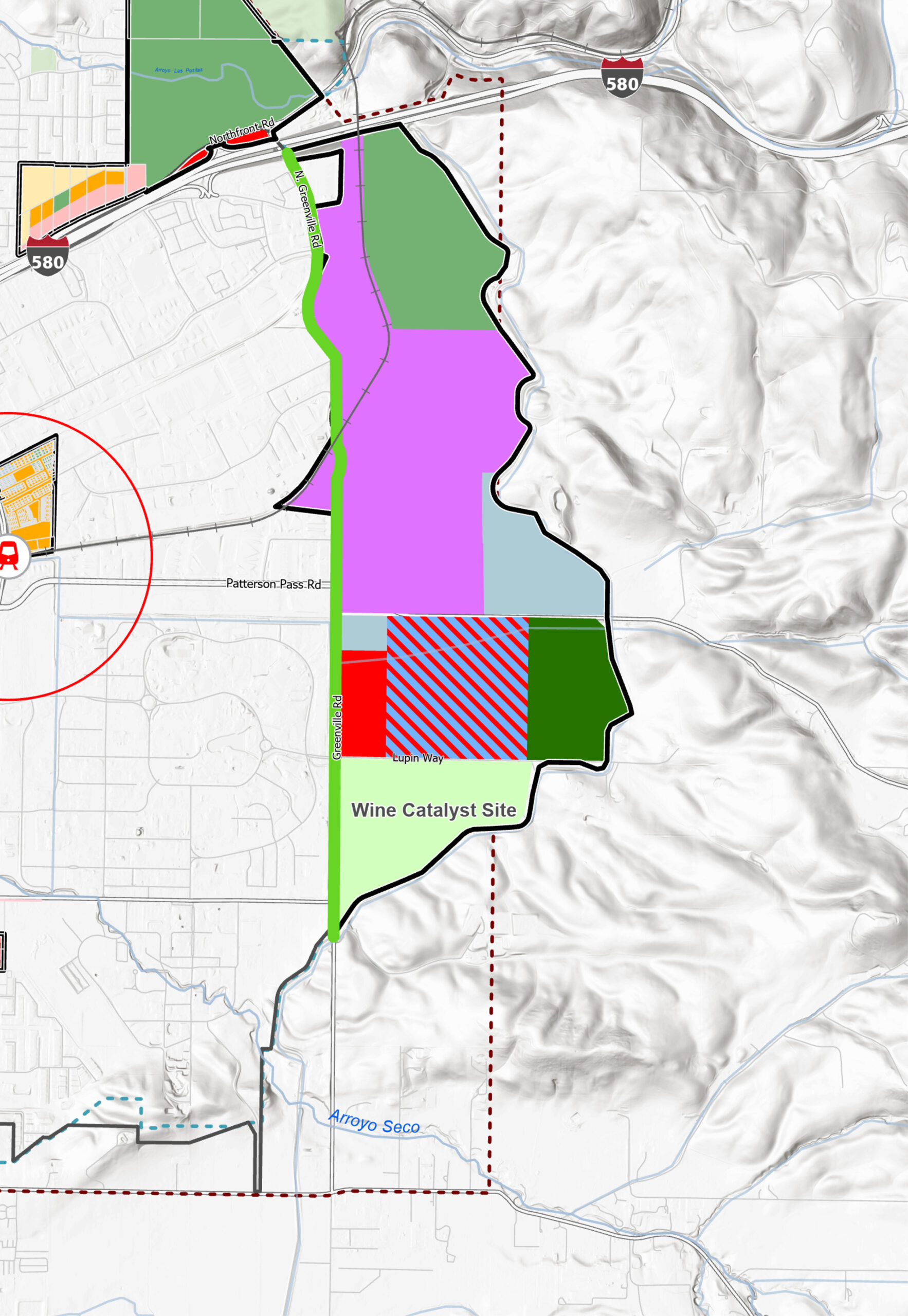
The East of Greenville focus area is approximately 1,139 acres, mostly located east of Greenville Road, and west of and south to the aqueduct. This focus area also includes a small pocket of land that located west of Greenville Road and currently in unincorporated Alameda County. This focus area is primarily undeveloped but does include scattered industrial and public uses and a few large lot rural residential homes. This area is outside the City Limits and the South Livermore Urban Growth Boundary, but mostly within the Sphere of Influence.
After preliminary evaluation of the General Plan land use alternatives, the General Plan Advisory Committee (a group made up of local Livermore residents) expressed concern that necessary improvements within the City could lead to the loss of industrial land and impact the City’s goals for job creation and a stable local economy. They also identified an interest in exploring opportunities for a research or educational campus and enhanced preservation of open space and vineyard areas in and around the study area. The GPAC also expressed concern with the land uses currently operating and expanding in the area under Alameda County land use jurisdiction. Based on the Advisory Committee’s recommendation, the City Council directed staff to include East of Greenville as a Focus Area.
The study is limited to the lands within the defined focus area. Lands considered recently by the Council for possible acquisition are located outside of the study area, are not contemplated for land use changes or development, and are being considered for open space purposes which include: non-motorized recreation, habitat and wildlife protection, watershed and land management, and climate resiliency to further the City’s conservation goals.
All alternatives incorporate these features:
Two of the alternatives include a park space to accommodate active recreation facilities. The 2017 LARPD Master Plan identified the need for additional sports fields that could not be accommodated through existing neighborhood serving parks. A facility of this kind at this location could accommodate organized sports and minimize the impacts such as lighting, noise, or other issues that could be considered a nuisance when programed near to existing neighborhoods. As part of the land use alternatives analysis, the project team will confer with the City’s partner, the Livermore Area Recreation and Park District (LARPD), to seek input on the feasibility of a park as part of the preferred land use scenario.
Table 1 shows the projected 2045 buildout for the East of Greenville focus area by alternative. The project team generated the development estimates calculating the minimum and maximum density range allowed by each Place Type. Table 1 uses the midpoint of these calculations. These calculations assume that every parcel would redevelop through the 2045 horizon, a scenario that is unlikely given historic development trends and potential parcel-level site constraints such as topography and biological constraints that cannot be projected at this large-scale analysis. In addition, the project team applied an industry standard factor that assumed a portion of each parcel would not be developed to account for roads, landscape setbacks, parking areas, and utilities.
As a reminder, employment forecasts for Livermore suggest the city could potentially add up to 21,300 jobs citywide by 2050. Further, based on state housing requirements estimates, the project team anticipates the need to plan for approximately 17,000-19,000 new housing units. Although the four focus areas inside the City Limits and other infill sites would also accommodate future job growth, the East of Greenville focus area provides an opportunity to capture jobs that could be displaced through infill development and achieve broader City economic goals.
| Demographics | Existing 2020 Conditions | Alternative A | Alternative B | Alternative C | |||
| 2045 Net New | 2045 Total | 2045 Net New | 2045 Total | 2045 Net New | 2045 Total | ||
| Households | 20 | 0 | 20 | 0 | 20 | 0 | 20 |
| Housing Units | 21 | 0 | 21 | 0 | 21 | 0 | 21 |
| Population | 55 | 0 | 55 | 0 | 55 | 0 | 55 |
| Jobs | 270 | 10,200 | 10,470 | 11,330 | 11,600 | 9,350 | 9,620 |
Source: City of Livermore traffic model and PlaceWorks.
The City, with assistance from the Rincon Consultants team, is studying the environmental impacts of potential land use changes within the East of Greenville focus area. The intent is to provide information to the community to facilitate community wide conversations and inform future decision making. The study includes analyzing the effects of development resulting from land use changes within the focus area.
Before any potential land use changes could occur, the City would need to apply to annex the focus area and adjust the City’s municipal boundaries, which is subject to Alameda County Local Agency Formation Commission (LAFCO) approval. Further, Livermore voters would need to decide to amend the Urban Growth Boundary to allow the City to provide municipal services (water, sewer, police, fire, sanitation, etc.) to the area. The intent of the EIR is to help inform these future decisions.
Consistent with state requirements and typical practice, the EIR will include alternatives evaluation and assess an alternative whereby no changes occur, known as the “no-project alternative.”
In addition to the East of Greenville EIR, the General Plan Land Use Alternatives Evaluation Report will examine the differences between various land use alternatives considered across the city into the horizon year 2045 and explore various trade-offs and considerations at a citywide scale in the development of a preferred General Plan land use map.
Before development could occur in this area, the City would need to undertake the following steps:
Completing all these steps will likely take many years before any development occurs, if ever, and is likely to extend beyond the 2045 horizon year of the General Plan. However, as the long-range future planning document for the City, it is appropriate to consider the potential pros and cons of land use changes outside the City’s current boundaries.
The City is considering purchasing several hundred acres of land in the Altamont Range outside of the East of Greenville focus area. The City’s interest in property acquisitions is for the conservation of open space for non-motorized recreation, habitat and wildlife protection, watershed and land management, and climate resiliency. Livermore has a history of leading open space conservation in the Tri-Valley and has successfully acquired, or helped partner agencies acquire, over 1,200 acres of open space.
Further, the City has permanently protected approximately 240 acres of its own land holdings through conservation easements, which are held by the Tri-Valley Conservancy and is in the process of protecting an additional 300 acres. Conservation Easements preserve these lands as open space and habitat forever.
Early community discussions regarding the Greenville area included exploring mechanisms that could further the community’s conservation priorities, such as the concept of creating a permanent greenbelt east of the aqueduct.
The City has existing policies and programs such as the South Livermore Valley Specific Plan in South Livermore and the Transfer Development Credit Program in North Livermore that can serve as successful models to explore similar approaches to open space conservation for the East of Greenville Area. Details of such a program will evolve at the General Plan policy level following community outreach and engagement.
City of Livermore
Planning Division
1052 S Livermore Ave
Livermore, CA 94550
(925) 960-4450